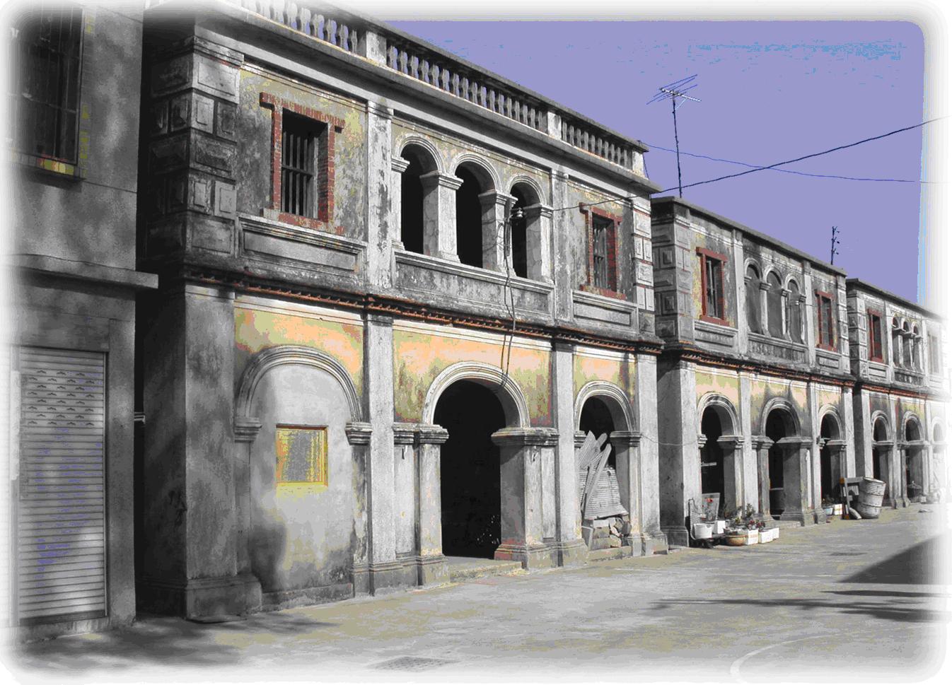
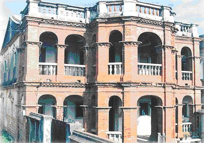
Communist Army’s Command Center (Beishan’s Ancient Western-styled Building) This large building located at the entrance to Beishan Village was used by PLA that landed in 1949 as a temporary command center to fight against our national forces that were after then. The bullet holes on the walls bear witness to the fierce battles. 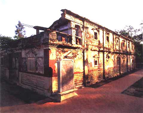
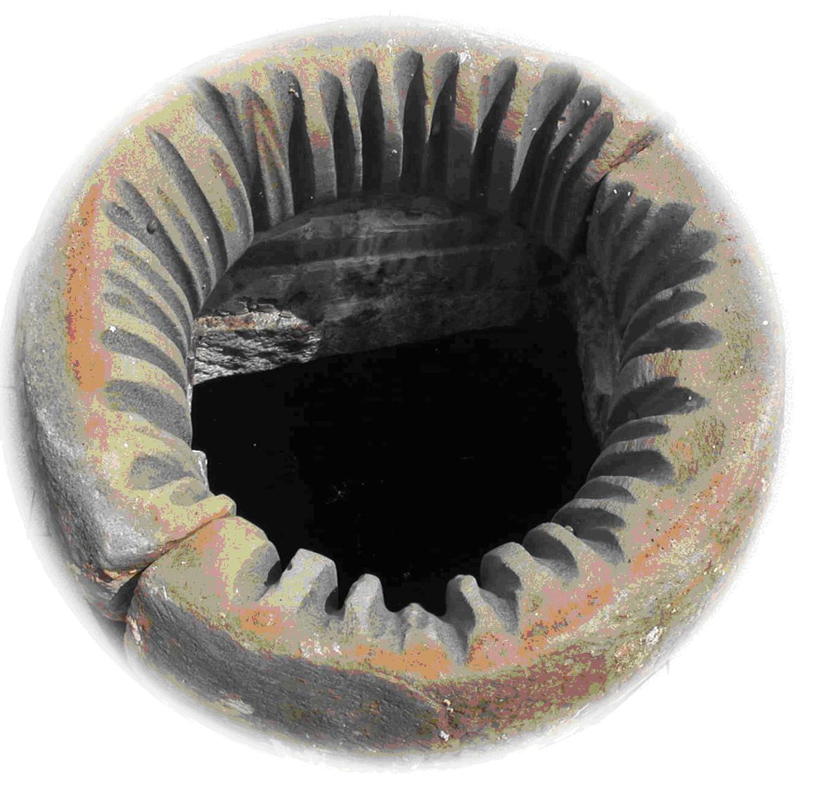
Tri-hole Well Legend has it that in the earlier days of the Kangsi Era, General Yong-ji Li who was stationed here once saw the villagers fight over the access to the well. He then had placed a cover with 3 holes on the well so people could access the water in a fair manner. The villagers then named it the “Tri-hole Well.” 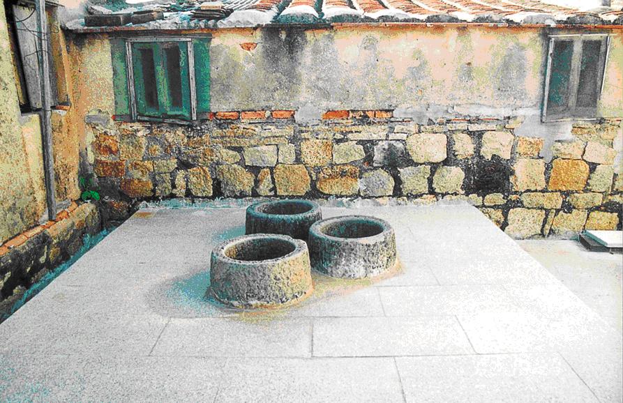 Tri-hole Well Tri-hole Well
Guangong’s Temple Guangong’s Temple is the guardian in Guningtou’s Nanshan, Beishan, and Lintsu. Built in the 13th year of Emperor Chianlong’s reign, this temple is now more than 200 years old and is the oldest one in the village. From the “feng-shui” perspective, the temple is located at a spot of lotus. During the era of sea transports, to celebrate the birthday of Master Guangong on June 24th (of the Lunar Calendar), two theater platforms would be placed in front of the temple, and the strange thing was there would also be room for people no matter how crowded it already was. During the 823 Cannon War, a large number of artillery shells were fired at Two-carpLake, yet Guangong Temple that was so close to combat zone was not damaged at all. Some artillery soldiers reported seeing a general in green robe wielding a huge blade on top of the temple. The national forces had problem closing the last gap of the Cihu Dike. An elder reported seeing a general dashing in and out of the gap on a white steed, and he believed that the gap was on the path that belongs to Master Guangong, and Cihu Dike would not be completed without his permission. 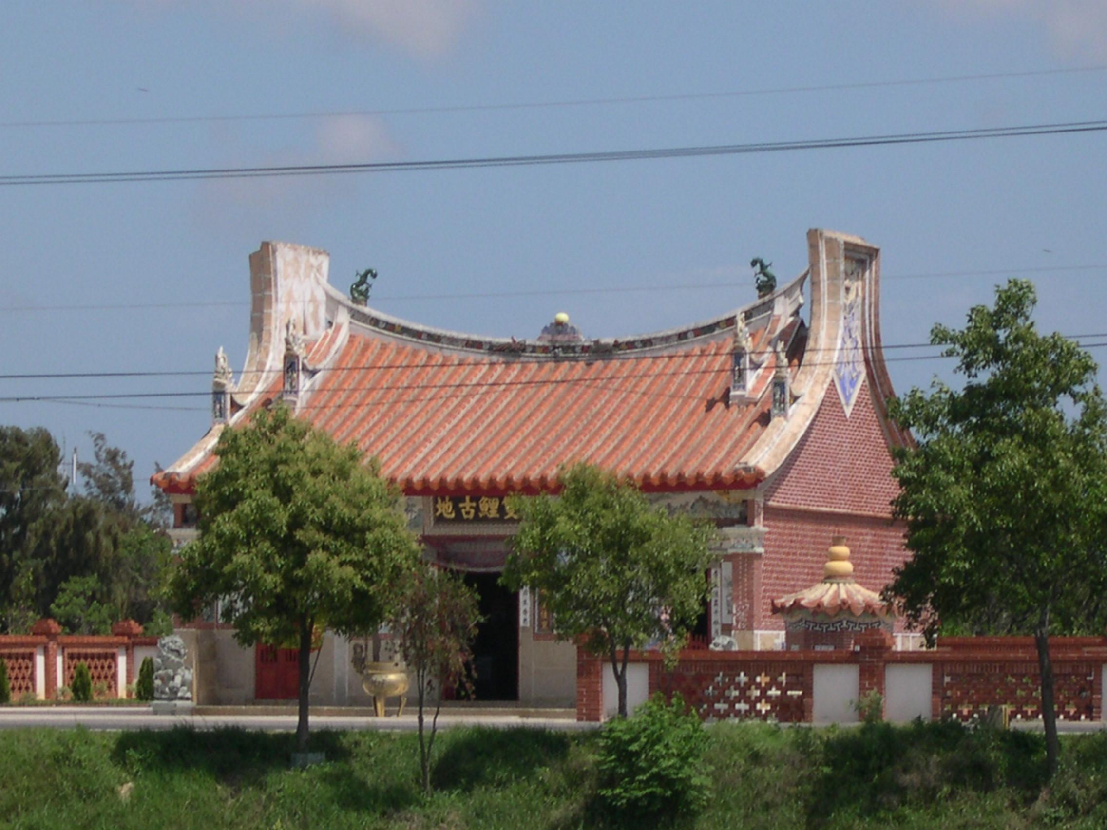 Monument of the Groom’s Tears This place is located by the gate of Wetland Natural Center. During the Japanese invasion, Kinmen also fell victim, and the people were forced to build airports and plant opium. On June 29, 1945, the Japanese military that was fighting a losing war forced 500 grooms in Kinmen and 500 donkeys to serve the military. With the Japanese army, these locals traveled towards Shantou via Haicheng and Changpu. Tragically, due to the bombing by U.S. warplanes, numerous grooms and donkeys were killed. Jin-chang Li, a survivor who originally came from Nanshan in Guningtou, asked the National Park to rise a stone monument that says “Groom’s Tears” in the place where the grooms set off in memory of the fallen countrymen. 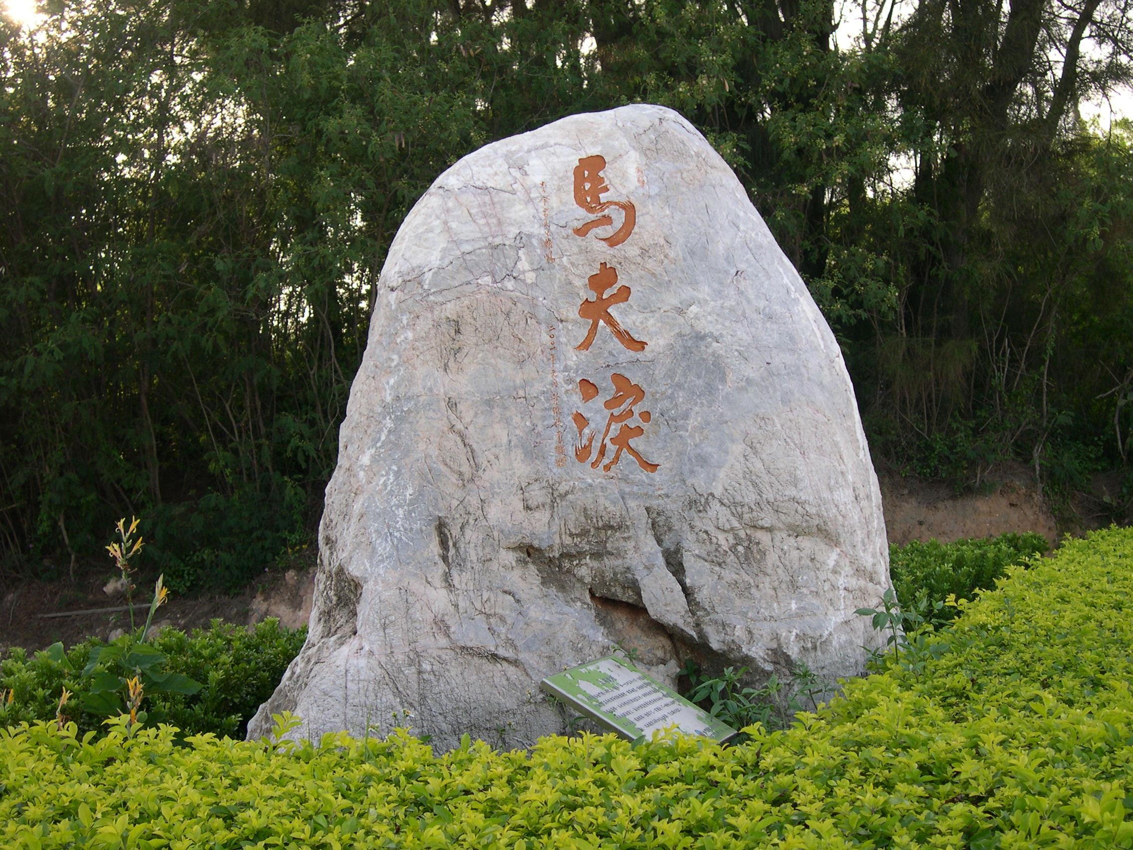 馬夫淚碑 馬夫淚碑
Cihu’s Natural Sceneries and Two-carp Wetland Natural Center in the National Park Completed in October of 2000, Kinmen National Park is an exhibition center for the natural and cultural environment of Kinmen and Guningtou. Cihu is the wetland with the richest life-forms in Kinmen. In winter, a large number of migratory birds spend time in Cihu and Two-carp Lake, making these places important spots for bird-watching. Cihu was also an important military facility, a dike constructed from the sea, and a great place for enjoying the sunset. Through the Center’s great design and multimedia, Kinmen’s natural environment can be easily understood here, making it a valuable and rare museum of ecology in Taiwan. 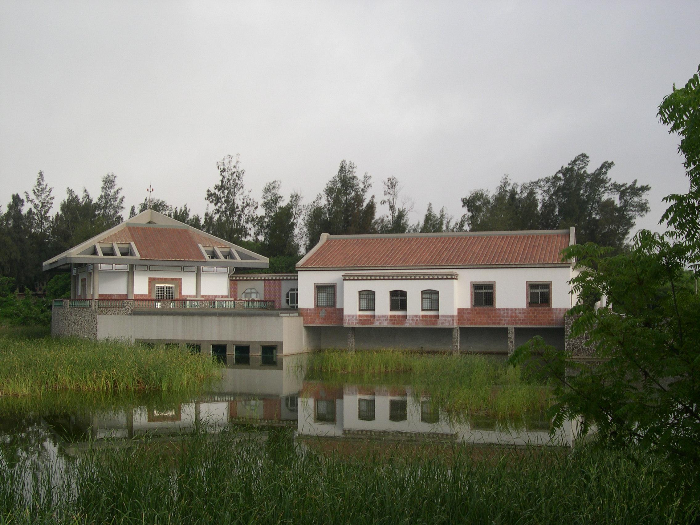
Two-carp Wetland Natural Center Wind-lion God, Ancient Western-styled Building, and Other Ancient Temple─ During a roughly 30 year time span from the 19th century to the 20th century, many people moved out of Kinmen to make money, and many of them would become successful and return to donate money to the homeland for building temples, schools, and homes, which were brilliantly constructed from mud and clay by experienced carpenters even when there were no blueprints. Today, these constructions are must-see sites for tourists who come here to appreciate the craftsmanship. Anmei Village Location and Terrain There are seven natural villages under the jurisdiction of Anmei Village, including Shihputou, Shanzao, Anchi, Hunan, Dongbao, Chungbao, and Shihbao. Located in the center of Jinning Township, Anmei Village faces Houjiang Sea to the north, joins Guning Village to the west, Hupu Village to the southwest, Panshan Village to the southeast, and Houpan Village to the northeast. oThis village also suffered dearly during the Cannon War, and the ground zero in this place was the Hunan Highland which was a military post for surveillance and observations. Shihputou is a small village in the northern region of Cihu, and most people here bear the family name “Chuang.” The “General Guang-chien Li Temple” in the village that receives a lot of visitors is dedicated to General Guang-chien Li who sacrificed his life for our country during the Battle of Guningtou. Guang-chien Li, with a middle name of “Fan-fu,” was born in Pingjiang County of Hunan Province and graduated from the infantry department of the Army School. In the Battle of Guningtou, he was hit by enemy fire and died at the young age of 32. In memory of his bravery, people in Kinmen dedicated December 25th as the Martyr’s Day and built the temple north of Shihputou, where many soldiers were killed. Arrow in a Rooster’s Beak Located near Anchi village, the “Arrow in a Rooster’s Beak” that faces the intersection is believed to be equally powerful as the Wind-lion God and Shihgandang in terms of fending off evil spirits. This statue was originally shorter, closer to the road, and badly weathered for the engraving to be seen. With the widening of the roads that are 120 steps away, the statue was restored and made bigger, with a “Bagua” on top of it and a colored rooster with an arrow in the beak. A stove beneath the rooster has engravings of words of luck and blessing on the left, right, and back sides. 
Houpan Village
Mt. Houpan is divided into Shangjing and Hsiajing. Most of the residents have the family name “Wang,” and a few also have the names such as Su and Tsai. Houpan was originally under the jurisdiction of Chiongshan; after Kinmen again became a county in 1953, Houshan was under the jurisdiction of Jinchyon Town. In 1965, Jinchyon became a part of Jinning Township, and Houpan Village then is consisted of four natural villages, including Houpan, Shihshan, Housha, and Longkou. Housha Village – Located at the center of Kinmen’s northern coastline, Housha is neighbor to Chionglin, Longkou, and Houpan about 1 km away. To its east is Taiwu, south is Shuang-ru Chingshan, and north is Houjiang Bay. The edge of the village is within 100 meters from the sea, from which one can see Pubian Cap and Chunglan Bay in the east, Longkou in the west, and Lintsu Bay in Guningtou. To the north are islands such as Dacheng and Hsiaocheng, and further north is Nan-an and Tong-an counties in China, which are only about 10km from Houpan. Houpan is known for its beautiful sceneries in Mt. Shuangru and is believed to have good feng-shui. Longkou Village – According to the local elders, the village is named Longkou (“Dragon’s Mouth”) since there is a Long Pond (“Dragon’s Pond”) west of the village that with spring water all year round. The Chinese character of the word “Long,” however, had been changed due to typo and was again changed to another word in 1965.
Houpanshan has red soil that is think and dense with poor water permeability but good filtration capability, thus the water well is deep with good water quality and was the water source for the entire village in the earlier days. Before, children or women often had difficulty pulling the water bucket all the way out from the bottom of the well with one try, and had to pull the rope against the well-fence, leaving permanent marks on the stones after years of abrasion. Due to the deep water of Houpanshan’s well (about 20~23 meters) that is only preceded by those in Tsuguoshan and Hou Lake, getting water out of the well is really difficult. It is said that bridges were tested for their arm strength before in order to make sure they can fetch water.
 Well-fence Well-fence Hupu Village
Located southwest of Jinning Township, Hupu Village is also the village that is closest to Amoy and is consisted of natural villages such as Hushia, Dongkeng, Puhou, Pubian, and Dingpuhsia.
The word “pu” in “Pubian” and “Dingpuhsia” refers to the fact that these two villages are near a plain. The origin of the name “Hushia” (“lower region of the lake”) is based on Anchi Lake, one of the five famous lakes in Kinmen; the lower region is where Hushia Village is located. In the earlier years of the Ming Dynasty, Chien-ye Yang, a government official settled and prospered here, and his village, “Hufeng,” now is Hupu Village of Jinning Township, Kinmen County. The highest place of the area is Mt. Yandun, from which one can see all corners of the village, making it an important military location. During the Ming and Cing dynasties, coastal areas were constantly raided by bandits, and the locals built their own watch-towers in order to fend off the criminals as the government was too powerless to help. At the first sign of bandits at night or day, fire or smoke would be started to alert the village. This mountain was thus named Mt. Yandun (“the mountain with smoke wood”).
Hushia Village is a coastal village where most people are farmers, and the rest are fishermen.
Due to the limited farm land and large population, people here have to rely on the sea for food sources. With the prospering industry of ash, there was demand for oyster shells, thus some people relied on opening oyster shells for making a living. The oil-pressing industry in Huhsia started as early as the end of Cing Dynasty, and the oil workshop behind the house of Kin-tang Yang (son of Ching-yuan) is where the oil-pressing industry was concentrated. Today, the site has been long abandoned, but the rare, ancient oil-pressing equipment are still kept in the location, despite the mess.
Huhsia Rice Flour Factory was established since the production of rice flour is quite easy, and such small-scaled operations can be handled by families without relying on employees. The low cost and good profit led to a dozen of rice flour makers at the peak of the industry, giving this village the name “Village of Rice Flour.”
There is one reason why rice flour factories in Hufeng quickly went out of business. The rice flour exported from Taiwan Island is well packed, low-priced, and delicious, which was proven too much for Kinmen’s industry to compete with. After 1960, there are no longer rice flour factories in Huhsia.
Sanjianlou in Huhsia 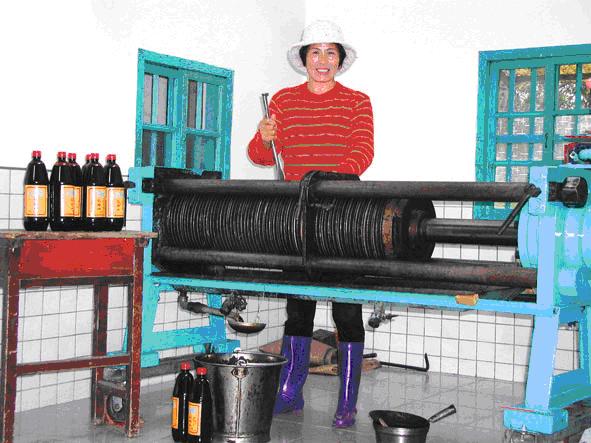 Process of Oil-pressing Process of Oil-pressing
Panshan Village Panshan Village is consisted of villages such as Dingbao, Hsiabao, Chientsu, Rushan, Jia Village, and Ren-ai New Village. Panshan Village is located at the inland in the western region of Kinmen Island. It was a village for the Weng family, but people of other family names also came and settled here.
1. Location and Terrain Panshan Village is located at the southeast region of our township. It joins Banglin to the south, Kincheng Township to the southwest, Hupu Village to the west, Hunan Village to the northwest, Dongbao to the north, Hsihshan Village to the northeast, and Mt. Houpan and Mt. Shuangru to the east.
Our village faces Mt. Shuangru and Mt. Fuding to the east, Chingshanping to the southeast, Mt. Changan to the west, Hunan Heights to the north, and Mt. Guanyinting and Mt. Shih to the northeast.
With mountains on all sides and a basin in the center, the southeast region of our village is slightly taller and leans towards the northwest.
Our village is only 2km away from Jincheng, the economic and cultural center of Kinmen.
We are about 4km away from the Guning Battlefield to the north, 5km from Mt. Taiwu to the east, less than 2km from Shangyi Airport to the southeast, and with Bo-yu Rd. that goes though the village from the southeast.
The difficult terrains make this place an important military location during war time. 2. Origin of the Names Our village was originally named “Chienbanshan Village,” although the true origin of the name can no longer be traced. Legend has it that the early settlers went up Mt. Taiwu from Houpu and stopped at Mt. Houban, which is about halfway, thus it was named Mt. Ban (“mid-point in the mountain”). Afterwards, when the Weng family moved to the village, Mt. Ban was renamed to Mt. Houban, and the village in the southern area was named Chienbanshan.
The ancestor of the Weng family, Kang-sou, traveled from Jinjiang and settled in Kinmen’s Houchoutsu during the Yuan Dynasty.
After Kang-sou died at a young age, his grandmother brought the two sons of Kang-sou to a relative’s place in Mt. Houban. The grandmother was buried in the area, and the sons lived here. Their descents moved to the southern area of Mt. Houban, where it was named Chienbanshan. Therefore, Chienbanshan Village is mostly occupied by the descents of the Weng family, whose activities were basically the history of this area.
This story is believed to be the most reliable reason why Chienbanshan Village was renamed to Panshan Village. A scholar in the Weng family went to the city for a national examination during the mid-Ming dynasty. The interviewer mocked him for living in “halfway of the mountain instead of the peak or the bottom.”
After failing the examination, he returned to his homeland and renamed the village to Panshan after discussing with the elders.
The Weng has documentations explaining why the place was renamed to Panshan. Basically, the village was like a round plate (“Pan” in Chinese) that is surrounded by Mt. Shuangru and Fuding in the east, Chingshanping and Mt. Jilong in the southeast, Mt. Dinghuo in the southwest, Mt. Changan in the west, Hunan Heights in the north, and Mt. Guanyin and Mt. Shih in northeast.
The mountains and heights are like “Bagua” that acts as the village’s natural barrier and keeps it from invasions.
Huwei River runs through the village and brings life. This place is blessed with natural resources, thus its name “Pan” is very meaningful since this world also means a “solid foundation” in Chinese. 3. Residents This village originally belonged to Guhuao. After reform, it was under the jurisdiction of Jinning Township and is the center of the village administration.
The ancient buildings in the village include “Shifenzai,” “East Dingbao,” “West Dingbao,” “East Hsiabao,” “West Hsiabao,” “Chientsu,” and “Hsiatien.” A disease broke out in Hsiatien in the earlier days, thus all the settlers have already moved out, making this place a ruin. The government has rebuilt this area, named it “Ren-ai New Village,” and relocated the town office, police station, health station, and library here, making it the important center of our village. After Bo-yu Rd. was developed, stores are opened along the road. A new, 8th location, “Bo-yi Neighborhood,” has been established in our village
 Panshan Village’s Red Building Panshan Village’s Red Building Banglin Village
1. Location
Located in the upstream of Wujiang River, this village that enjoys good feng-shui is close to Mt. Shihmu, Mt. Wuchiu, and Mt. Denghuo. Most houses here are configured east-west, followed by north-east. Only one house faces east.
2. Origin of the Name
According to the ancient documents, this village was originally named Donglin, and was possibly named Donglin or Chulin. After a forest fire broke out in the east in one year, people realized it was a good place to live due to the flat terrain and protection from the wind and moved in. The name changed to “Banglin” after the KMT government stationed here. History
Legend has it that Donglin was founded by the Wang family. After a large number of settlers came here, this place became very crowded and prosperous.
In 1068, our village was under the jurisdiction of Tongan County. Huande Township’s Hsiangfeng Neighborhood, Banshan, Gulongtou, and Houchi all belonged to Shihjiudu.
In 1821, our village belonged to Mahsiang Hsiangfeng Neighborhodo, and belonged to Shihjiudu with Houpu, Puhsia, Pubian, Dongchou, Houchi, Houhu, and Shugaoshan.
In 1915, Kinmen became a county. Our village still belonged to Houpubao, and Shihjiudu was renamed to “District 1.”
In 1935, self-governance was carried out in our county. Houpu, Guhsian, and Guhu belonged to District 1. In 1945, when Taiwan was returned to the KMT government, two townships and four villages are established here, and our village belonged to Guhu Township.
In 1949, we belonged to Jinning District.
In 1952, five districts were established in our county. Our village belonged to Jinning District. In 1953, Kinmen was given back its county status. Districts became townships, and our village belonged to Jinning Township.
In 1965, Banglin Village included Banglin, Hsiguoshan, and Dongchou. In 1994, it included Banglin, Hsiguoshan, Dongchou, Houhu, Dinghouan, and Hsiahouan. 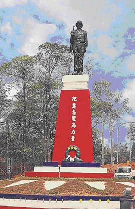
|